

Megaregions are massive interconnected cities scattered throughout the United States, e.g. the Houston/Austin/Dallas Triangle, and the America 2050 initiative is putting them under the microscope (metaphorically speaking). Their about page says, “America 2050 is a national initiative to meet the infrastructure, economic development and environmental challenges of the nation as we prepare to add about 130 million additional Americans by the year 2050.”
If you’re doing business research- especially research concentrated around megaregions- then their site is a veritable goldmine of information. America 2050 features free reports on topics ranging from energy & climate, high speed rail, broadband infrastructure, commuter patterns, etc.
Beyond the sheer concentration of data and analysis packed in America 2050's content, their maps are an excellent highlight. The main maps page features many versions of the national-level megaregion concentrations, plus proposed passenger transit lines throughout the US.
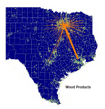
Furthermore the incredibly detailed region-specific reports found in the Research tab have maps illustrating economic interrelationships among cities, e.g. wood products’ traffic concentrations within the Texas Triangle.
For those who want to keep abreast of the major economic, environmental, infrastructure and transportation trends that are shaping America’s most heavily populated and trafficked areas, this site is definitely one to bookmark.